![]()
![]()
![]()
![]()
![]()
![]()
![]()
![]()
![]()
![]()
![]()
![]()
![]()
 Map 9 ~ In the Shadow of Mt. AscutneyPrinter friendly map
 Sumner Falls marks the approximate half-way
point of the Connecticut River’s trip from
Canada to the sea. This series of ledges requires a
portage. Be sure to consider the strength of the
current in preparing to land on the VT side. This
is a dangerous area, and boaters have lost their
lives here. Because of the presence of endangered
species, please do not walk on rocky outcrops at
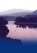
the top and middle of the falls on Hart Island, 3 miles below the falls, is not open to public use. Mt. Ascutney, inspiration for the Cornish colony of artists settling nearby in the last century, drifts in and out of view until you round the bend above the Cornish Windsor Covered Bridge. This is the longest historic wooden covered bridge in the US, and has been replaced four times. Below the railroad bridge is Chase Island, owned by NH Fish & Game Dept. Chase Island is NOT open to public camping. Please do not disturb cobbles, collect plants, or build fires. Avoid walking on the upper part of the cobble beach near the island’s north end. The river is too narrow throughout this section for legal use of ski craft. Information on current and projected flows at Connecticut River mainstem dams is available through TransCanada Hydro Northeast. Marine Patrol: Toll Free in NH (1-877-642-9700) or 603-293-2037. For the safety of all, please call if you observe illegal or dangerous boating activity. |
 The
Connecticut River islands are home to several rare,
threatened and endangered species. In fact, this
section of the river is sometimes called the
Connecticut River Rapids Macrosite because the
highest concentration of globally rare species in
all of Vermont and New Hampshire occurs in this
stretch.
The
Connecticut River islands are home to several rare,
threatened and endangered species. In fact, this
section of the river is sometimes called the
Connecticut River Rapids Macrosite because the
highest concentration of globally rare species in
all of Vermont and New Hampshire occurs in this
stretch. the
NH side of the river, and avoid trampling
vegetation in other rocky areas. Beware of poison
ivy.
the
NH side of the river, and avoid trampling
vegetation in other rocky areas. Beware of poison
ivy.