![]()
![]()
![]()
![]()
![]()
![]()
![]()
![]()
![]()
![]()
![]()
![]()
![]()
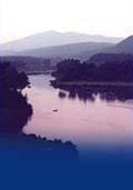
 Map 8 ~ Upper ValleyPrinter friendly map You may share the river in this region not only
with canoeists and kayakers but also with the
Dartmouth College crew team. In this heavily
settled part of the Upper Valley, boaters with an
eye for beauty can appreciate the There is a 1000' no-wake zone upstream from the Ledyard Bridge. Watch for swimmers. A quick paddle under the old stone arch railroad bridge on the VT side will bring you to a landing and trails to the Montshire Museum. Here you will find exhibits on the Silvio Conte National Fish & Wildlife Refuge, focused on the Connecticut River. The river gathers behind Wilder Dam, a hydro power producer built in 1950 to take advantage of the river’s frothy drop over Olcott Falls. The area just above and within sight of the dam is the only part of the river in this section that is wide enough for legal use of ski craft. Please note that the river access at the Hanover Wastewater Treatment Plant is now closed. Below the dam, the river is once again passable only by canoe and kayak. Since the time of the log drives, this has been a section known for its strong currents. Flows now depend upon releases of water from Wilder Dam, and flows from the White River. The White River is one of New England’s largest free-flowing rivers; when there are heavy rains in its watershed, the White has been known to swell to twice the volume of the Connecticut’s mainstem. Paddlers will experience fast, often shallow water, short sections of rapids, and changing water levels as far as the mouth of the Ottauquechee River. Paddlers who want just a quick trip from Blood Brook or to Sumner Falls can use the Ottauquechee River Access inside the mouth of this tributary, off Mill Street in Hartland just north of a pair of covered bridges. Information on current and projected flows at Connecticut River mainstem dams is available through TransCanada Hydro Northeast. Marine Patrol: Toll Free in NH (1-877-642-9700) or 603-293-2037. For the safety of all, please call if you observe illegal or dangerous boating activity. |
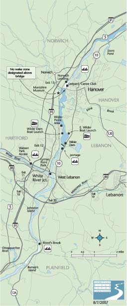 foresight
of Dartmouth alumni who purchased and preserved the
Pine Park area just north of the college’s
boat house. The Ledyard Bridge, which carries the
Appalachian Trail - and other traffic - between
Hanover and Norwich, is the fifth on the site,
replacing a series of covered and later concrete
bridges.
foresight
of Dartmouth alumni who purchased and preserved the
Pine Park area just north of the college’s
boat house. The Ledyard Bridge, which carries the
Appalachian Trail - and other traffic - between
Hanover and Norwich, is the fifth on the site,
replacing a series of covered and later concrete
bridges.