![]()
![]()
![]()
![]()
![]()
![]()
![]()
![]()
![]()
![]()
![]()
![]()
![]()
 Map 7 ~ Lyme/ThetfordPrinter friendly map
The river is too narrow throughout this section for legal use of ski craft. Enjoy birdwatching at the many setbacks where tributaries enter the mainstem. Providing valuable waterfowl habitat, many of these wetlands have been protected by the states and the Upper Valley Land Trust in concert with the towns. Lyme has added a canoe access at the mouth of Hewes Brook as part of one such protection project. For boating services, Fairlee Marine is located just off the river at the south end of Fairlee village. Information on current and projected flows at Connecticut River mainstem dams is available through TransCanada Hydro Northeast. Marine Patrol: Toll Free in NH (1-877-642-9700) or 603-293-2037. For the safety of all, please call if you observe illegal or dangerous boating activity. |

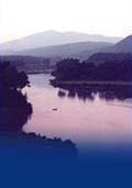
 While
the river has gained some width from tributaries
large and small, it has not left the problems of
erosion behind. Watch your wake carefully, and
remember to reduce speed while passing other
boaters and the piers of the North Thetford bridge,
one of hundreds of covered bridges lost during the
flood of 1936.
While
the river has gained some width from tributaries
large and small, it has not left the problems of
erosion behind. Watch your wake carefully, and
remember to reduce speed while passing other
boaters and the piers of the North Thetford bridge,
one of hundreds of covered bridges lost during the
flood of 1936.