![]()
![]()
![]()
![]()
![]()
![]()
![]()
![]()
![]()
![]()
![]()
![]()
![]()

 Map 4 ~ Lower Fifteen Mile FallsPrinter friendly map
TransCanada Hydro Northeast maintains several public boat launches and picnic areas on Comerford Reservoir for day use. Below Comerford, the Connecticut River becomes narrow, the province of canoeists and kayakers again. Paddlers should watch for large rocks in the first two miles below the dam. At the confluence of the Passumpsic River, you can see the remains of ancient flood plain forests on the so-called Nine Islands, whose number actually varies depending on the water level.
Information on current and projected flows at Connecticut River mainstem dams is available through TransCanada Hydro Northeast. The river continues as canoeing water for the most part, except for the pool above Dodge Falls Dam. Marine Patrol: Toll Free in NH (1-877-642-9700) or 603-293-2037. For the safety of all, please call if you observe illegal or dangerous boating activity.
|
 Below
Moore Dam, the Connecticut River immediately enters
Comerford Reservoir, another eight miles of
excellent boating and fine fishing for both trout
and bass, all with memorable views of the
Presidential Range of the White Mountains to the
east. Boaters should watch for canoeists and other
small craft. Ski craft may only be used on the
impoundments, and must stay 300' from shore,
islands, and other boats.
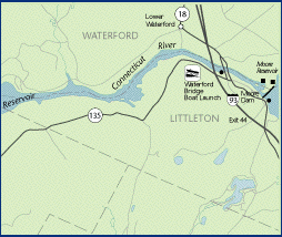
Below
Moore Dam, the Connecticut River immediately enters
Comerford Reservoir, another eight miles of
excellent boating and fine fishing for both trout
and bass, all with memorable views of the
Presidential Range of the White Mountains to the
east. Boaters should watch for canoeists and other
small craft. Ski craft may only be used on the
impoundments, and must stay 300' from shore,
islands, and other boats.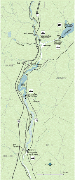 Be
alert since water levels rise rapidly as generators
come on line, and what was safe water one minute
could be too shallow the next. Do not anchor your
boat near the base of Moore Dam: should the
generators come on line while you are there, the
water may rise too fast for you to cut your boat
loose.
Be
alert since water levels rise rapidly as generators
come on line, and what was safe water one minute
could be too shallow the next. Do not anchor your
boat near the base of Moore Dam: should the
generators come on line while you are there, the
water may rise too fast for you to cut your boat
loose.