![]()
![]()
![]()
![]()
![]()
![]()
![]()
![]()
![]()
![]()
![]()
![]()
![]()
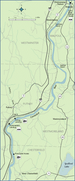
 Map 12 ~ Westminster/WestmorelandPrinter friendly map.
Connecticut River islands are special places. To protect habitat for rare species on Walpole Island, please do not disturb cobbles, collect plants, or build fires, and avoid walking on the upper part of the cobble beach near the north end. Dunshee Island is owned by the NH Fish & Game Dept. Notice the remnants of silver maple flood plain
forest which once clothed the riverbanks
throughout. These forests are specially adapted to
changing flows, and don’t mind getting wet
feet. Besides protecting the banks from scouring
and ice, flood plain forests shelter migrating
birds on their way north in the spring, and usher
them home in fall. They also protect water
In fact, one of the best things YOU can do to improve the boating experience on a river is to safeguard a buffer of vegetation along your home stream, whether it’s a tiny tributary or the mighty Connecticut itself. For more information, call CRJC at 603-826-4800. The river is too narrow throughout this section for legal use of ski craft. Information on current and projected flows at Connecticut River mainstem dams is available through TransCanada Hydro Northeast. Marine Patrol: Toll Free in NH (1-877-642-9700) or 603-293-2037. For the safety of all, please call if you observe illegal or dangerous boating activity.
|
 Much
of the beautiful scenery that surrounds the river
is brought to you by valley farmers, who value
their productive soil and appreciate your care with
your boat wake. Some of these farms have been
permanently protected.
Much
of the beautiful scenery that surrounds the river
is brought to you by valley farmers, who value
their productive soil and appreciate your care with
your boat wake. Some of these farms have been
permanently protected. quality
for swimming and fishing, by filtering out
pollution and sediment coming off the land.
quality
for swimming and fishing, by filtering out
pollution and sediment coming off the land.