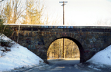
Stone Arch Underpass |
|
|
Site: N10-8
|
National Register Nomination Information:
DESCRIPTION: Spanning between two banks of land flanking Glen Road, this stone arch served as an overpass for heavy railroad traffic for over 136 years prior to the recent, currently in-progress abandonment of this line of the Northern Railroad. The underpass is located approximately 250 feet west of the Mascoma River with this section of Glen Road running parallel to the River with a north-south orientation. The overpass is located approximately .5 miles south of Route 4 and .5 miles east of Route 12A. The arch measures 12 feet high, 18 feet wide and 12-1/2 feet deep. It is constructed of mortared, irregularly sized stone blocks, many displaying chisel marks where they were extracted from bedrock. Voussoir stones form the arch itself, each averaging about 1-1/2 feet high and 21/2 feet wide. Metal tie rods are spaced intermittently in a horizontal line over the arch. A concrete slab caps the arch, acting as a foundation for the train tracks, its total length is approximately sixty feet long, with the stone work of the underpass staggered down the hillside from the ends of the concrete cap. Perhaps the most photographed feature in Lebanon throughout the years, photographs indicate little difference between its present and historical appearance, save for the spray-painted initials of vandals and unrestrained vegetation. The addition of the concrete cap, metal tie rods and mortar to the original loose stone blocks all represent modern reinforcement and repair efforts. Located on a dangerous curve in the road, its narrow opening limiting the passage of a single lane of traffic at one time, the overpass' future is inevitably threatened by road widening in the future. The Stone Arch Bridge is numbered 141.35 by the B & M Railroad.
Skillfully built of loose stone blocks, the Stone Arch bridge is the only one of Lebanon's railroad bridges to survive, relatively unchanged after over 125 years of heavy traffic. According to railroad historian Edgar Mead, the Bridge is among the most historically interesting and valuable bridge structures in western New Hampshire. A unique structure, there are not known to be any similar stone arch railroad bridges of this age and proportion in the area.* Built under the direction of Northern Railroad engineers, the designer of the bridge is not known for certain but may have been H.R. Campbell, chief engineer of the Northern Railroad who superintended construction of numerous bridges in the area from about 1848-1859. It is interesting to note that during this same period Campbell commissioned Lebanon native Ammi B. Young to design what is now the Carter Homestead on Bank Street in Lebanon for his use. (see Colburn Park Historic District nomination, pending 1985). * Letter from Edgar Mead to Liza Mausolf dated January 17, 1985 (Upper Valley-Lake Sunapee Council files). The author of numerous books on railroads, Mr. Mead is a director of the National Railway Historical Society.
Chapman, Bernard. Lebanon, New Hampshire: History in a Nutshell. Lebanon Historical Society, 1958. Leavitt, Robert H. & Bernard Chapman. 50 Old Bridges of Lebanon, N.H. (Lebanon, N.H. Lebanon Historical Society), 1975. Information on H. R. Campbell from his great-granddaughter, Mrs. E. R. Saddler, Akron, Ohio. Letter to Robert Leavitt, 1976. Lebanon Historical Society collection. Letter from Edgar T. Mead to Lisa Mausolf, dated January 17, 1985. (Upper Valley-Lake Sunapee Council files).
DATE ENTERED: September 12, 1985.
|
BACK TO NATIONAL REGISTER PROPERTIES