![]()
![]()
![]()
![]()
![]()
![]()
![]()
![]()
![]()
![]()
![]()
![]()
![]()
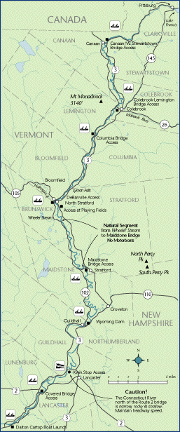
 Map 2 ~ The North CountryClick here for printer friendly maps of Canaan to Columbia and Stratford to Lancaster The river drops 400 feet between Murphy Dam at the foot of Lake Francis and the N. Stratford/Bloomfield bridge, a distance of some 35 miles as the trout swims. For the most part, this is canoe, kayak, and wader water.
Shallow drafted boats will find the river easier going between the Route 2 bridge and Gilman Dam. If you do use a propeller, please do not create a wake: riverbank washing into the water adds sediment which covers trout spawning habitat. Avoid climbing on eroding banks. Please ask landowner permission, if you cross private land to reach the river, and treat the land as carefully as you would your own. Carry out what you carry in. Leave crops and standing grass undisturbed, and close pasture gates behind you. Leave your vehicle where it will not obstruct access to farm fields or equipment. The breached dam at Lyman Falls, 8 miles below the Columbia covered bridge, is a place to pull out and scout ahead. The falls can sometimes be run, especially on the NH side, but it is better to plan on a portage, especially if your skills or the water level aren’t up to it. In the fall of 2001, the old dam's dangerous exposed spikes and metal rods were removed by a crew working for the Connecticut River Joint Commissions, making this area much safer for paddlers and swimmers. The State of Vermont has established Lyman Falls State Park here, with help from CRJC. Wild brook trout are one of the Upper Connecticut’s many treasures. Fishermen should know about the catch-and-release section (use barbless hooks) designated from a point 250' below Lyman Falls to 1600’ above the N. Stratford/Bloomfield bridge. A new access for fishing and cartop boats has been added in the village of Bloomfield, Vermont, just upstream from the confluence of the Nulhegan River. Park on the west side of Route 102. Here you will find an exhibit erected for the Northern Forest Canoe Trail. The river’s exceptional natural beauty here
was recognized by an act of the New Hampshire
legislature in 1992: the seven mile stretch of the
Connecticut from the mouth of Wheeler Stream
opposite Stratford to the c. 1885 steel truss
bridge between Stratford and Maidstone is the only
segment of the Connecticut River officially
designated as “natural”. No motors may
be used on this section. In the section from Stratford to Gilman, the river shifts from quick water to meandering across a valley of rich soils, taking shortcuts during high water and creating oxbows. In at least one place, a Vermont farmer can watch the sun set over New Hampshire. The natural valley flood storage offered by the open lands near the river helps prevent flooding downstream. The breached Wyoming Dam at the Guildhall/Northumberland bridge is dangerous and should be portaged on the Vermont side, using the trail indicated by signage. At the Mt. Orne Covered Bridge between Lancaster and Lunenburg, use the parking area and stairs on the Vermont side. Marine Patrol: Toll Free in NH (1-877-642-9700) or 603-293-2037. For the safety of all, please call if you observe illegal or dangerous boating activity. Information on current and projected flows at Connecticut River mainstem dams is available through TransCanada Hydro Northeast. |